Traveling Salesman Problem (TSP) v4
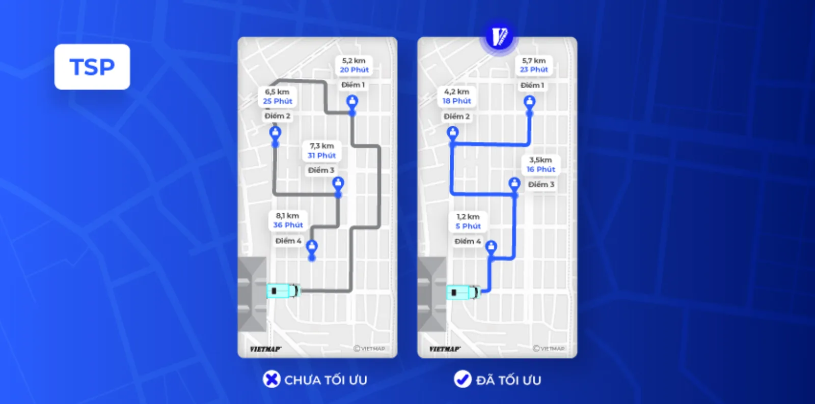
TSP v4 takes a list of points and returns the route for one vehicle through all of them with the lowest total driving time, with geometry and turn-by-turn instructions. Times come from the VIETMAP road network for the given vehicle (one-way streets and restrictions included). By default the route returns to the first point; change that with roundtrip, sources and destinations. For more than one vehicle use VRP.
Try it in the Playground
Call TSP v4 with real data, no code required: Open Playground
AI Agent Integration  NEW
NEW
Download the optimized doc for AI agent integration (Matrix + TSP + VRP): Logistics Agent Doc
Or try it in Postman.
TSP or VRP?
| Your situation | API |
|---|---|
| One vehicle, many stops — just tell me the order | TSP v4 (this page) |
| Several vehicles — decide who takes what, then order each route | VRP |
| I want raw travel times and will plan myself | Distance Matrix |
| I know the order already, I need the road path | Routing |
Common setups
| Situation | Parameters |
|---|---|
| Start and end at the depot | roundtrip=true (default) |
| Start at the depot, end anywhere | roundtrip=false&sources=first |
End at the last point you sent |
roundtrip=false&destinations=last |
| Need opening hours or load limits | use VRP (time_windows, capacity) |
Costing
A TSP request is billed as one transaction per stop — a 20-stop tour costs 20 transactions. See How Pricing Works.
URL
https://maps.vietmap.vn/api/tsp/v4?apikey={your-apikey}&point={point}&point={point}&point={point}&points_encoded={points_encoded}&vehicle={vehicle}&roundtrip={roundtrip}&destinations={destinations}&sources={sources}
Method
GET
Migrate from v3 → v4
- The endpoint changes from
/api/tsp/v3to/api/tsp/v4. - TSP v4 runs on the same v4 routing engine as Route v4, so results are consistent with v4 routes.
- The request parameters and the response format are unchanged, so migrating is a matter of updating the URL.
See the previous version docs: TSP v3.
Parameters
| Parameter | Type | Required | Default | Description |
|---|---|---|---|---|
| apikey | string | yes | none | API key provided by VIETMAP for your account. Register here |
| point | array string | yes | none | The points for which the route should be calculated. Format: [latitude,longitude]. Specify at least an origin and a destination. Via points are possible. The maximum number depends on your plan. |
| points_encoded | boolean | no | true | Allows changing the encoding of location data in the response. The default is polyline encoding, which is compact but requires special client code to unpack. Set this parameter to false to switch the encoding to simple coordinate pairs like [lon,lat]. See the description of the response format for more information. |
| vehicle | string | no | car | Enum: car, motorcycle, truck, container. The vehicle profile for which the route should be calculated. |
| roundtrip | boolean | no | true | true (default): the route returns to the start point. false: open route; where it starts and ends is controlled by sources/destinations. |
| sources | string | no | any | any (default): the solver picks the start point. first: the route must start at the first point sent. |
| destinations | string | no | any | any (default): the solver picks the end point. last: the route must end at the last point sent (use with roundtrip=false). |
Example
Input
https://maps.vietmap.vn/api/tsp/v4?apikey={your-apikey}&point=10.79628438955497,106.70592293472612&point=10.801891047584164,106.70660958023404&point=10.801595962927763,106.6898296806408&points_encoded=true&vehicle=motorcycle&roundtrip=true
{
    "license": "vietmap",
    "code": "OK",
    "messages": null,
    "paths": [
        {
            "distance": 7720.5,
            "weight": 1022.8,
            "time": 1022800,
            "transfers": 0,
            "points_encoded": true,
            "bbox": [
                106.68973,
                10.79352,
                106.71098,
                10.80307
            ],
            "points": "}s{`Ac_hjSIP[r@KTuAxCOb@QVuAoAi@g@w@u@oCmC_BgBm@}@QUcB{C}@qBMYs@{B]}A_@kBSkCIo@oABFbAHtAPtAPpAbApDXv@Rj@dAzBT^dAdBqA^e@Jo@F{BLCcAAEICq@@p@AHB@DBbAzBMn@Gd@KpA_@LRZh@dAvAv@z@pI`I[t@u@vA|@h@LJDLa@jL?`AF^gBVeF~@GZuAb@sARgDr@uHfBa@PGBd@xAF\\?RGz@WnEk@~HSzCUlDH?bB?TnAJbAH|@?VBz@?j@?JGJGXGf@?n@Db@H~BjCn@?B?JAFI?}BCAcAI_CEc@?o@Fg@FYFK?K?k@C{@?WI}@KcAUoAdAAz@CP?`A?b@?z@CbAI\\E^GHAJ?VClAGbBGPA`ACLAv@CH?~BOj@C~@Al@Ar@C@kADKbDJ~@Bh@LGk@Bo@H[T[TOPGNCNA`AFlA@REVSFIFQBYGkA@{@Ig@[_AA}B@y@Hq@BO@g@EmAAWCg@Ac@BwAX_DHs@H{@DUP_@No@Be@?KEMGd@GJIDE?k@i@Q?WJGG}AqA?a@mAoAeDcDQQUUyEmEPWNc@tAyCJUZs@HQ",
            "instructions": [
                {
                    "distance": 192,
                    "heading": 0,
                    "sign": 0,
                    "interval": [
                        0,
                        6
                    ],
                    "text": "Tiếp tục theo Đường Nguyễn Cửu Vân",
                    "time": 25900,
                    "street_name": "Đường Nguyễn Cửu Vân",
                    "last_heading": null
                },
                {
                    "distance": 0,
                    "heading": 0,
                    "sign": 4,
                    "interval": [
                        201,
                        201
                    ],
                    "text": "Đích đến",
                    "time": 0,
                    "street_name": "Đường Nguyễn Cửu Vân",
                    "last_heading": null
                }
            ],
            "snapped_waypoints": "}s{`Ac_hjS}`@{CVphB"
        }
    ]
}
Response truncated; middle elements omitted.
Response description
| Field | Type | Description |
|---|---|---|
| license | string | The type of license for the map data. |
| code | string | A code indicating the status of the response. Details at Status Code Values |
| messages | null | Messages associated with the response, if any. |
| paths | array | An array containing route information, such as distance, time, and instructions. |
Each object in the paths array contains the following fields:
| Field | Type | Description |
|---|---|---|
| distance | float | The total distance of the route (in meters). |
| weight | float | The weight of the route. |
| time | integer | The total time required to travel the route (in milliseconds). |
| transfers | integer | The number of transfers during the route. |
| points_encoded | boolean | Indicates whether the points are encoded. |
| bbox | array | The bounding box of the route. |
| points | string | Encoded points along the route. |
| instructions | array | An array containing step-by-step instructions for navigating the route. |
| snapped_waypoints | string | Snapped waypoints along the route. |
Each object in the instructions array contains the following fields:
| Field | Type | Description |
|---|---|---|
| distance | float | The distance of the instruction. |
| heading | integer | The heading direction of the instruction. |
| sign | integer | The sign indicating the action to take (e.g., turn left). |
| interval | array | The first and last index (of the points list) of the route section covered by this instruction. |
| text | string | The textual instruction for navigating. |
| time | integer | The time required to complete the instruction. |
| street_name | string | The name of the street for the instruction. |
| last_heading | null | The last heading direction for the instruction. |
Status Code Values
OK: The request was successful and the response contains valid data.INVALID_REQUEST: The request parameters failed validation. Details about the validation errors are provided in the messages field of the response.OVER_DAILY_LIMIT: The daily request limit for your API key has been exceeded. No further requests will be processed until the limit resets.MAX_POINTS_EXCEED: The number of points in the request URL exceeds the allowed maximum for your plan. Reduce the number of points and try again.ERROR_UNKNOWN: An unexpected error occurred while processing the API request. Please check the messages field for more information or contact support if the issue persists.ZERO_RESULTS: No viable route was found between the requested waypoints.
Frequently asked questions
When do I get ZERO_RESULTS?
When no road path connects all the point values sent for the selected vehicle. Check the coordinate order first (latitude, then longitude); if you are using vehicle=truck or container, call again with vehicle=car to see whether a point sits on a road closed to trucks.